TROPICAL REVOLVING STORMS
A tropical revolving storm or a TRS is a storm system with a low-pressure centre, around which winds of gale force (34 knots or force 8) or more blow spirally inwards, anticlockwise in the Northern Hemisphere (NH) and clockwise in the Southern Hemisphere (SH).
TRS is common in various places in the world, but they can be called as below:
- “Cyclones” is used in the Bay of Bengal and the Arabian Sea.
- “Hurricane” is used on the western side of north Atlantic and south Pacific.
- “Cordonazo” is used on the eastern side of North Pacific.
- “Typhoon” is used on the western side of North Pacific.
- “Willy – willy” is used on the eastern side of South Indian Ocean.
Cause
- Warm( over 27C) moist air rises from the surface of the sea.
- As it rises it meets cooler air and condenses to make clouds and rain.
- This condensation releases huge amounts of energy, producing strong winds.
- The winds are driven by the spin of the earth and go round and round.
- As the earth rotates the winds are sucked violently upwards in a vortex which can be 1,000km wide. Wind speeds can be as high as 200km per hour.
- These storms are fuelled by damp air when they reach land, dry air is being sucked up and they loose energy.
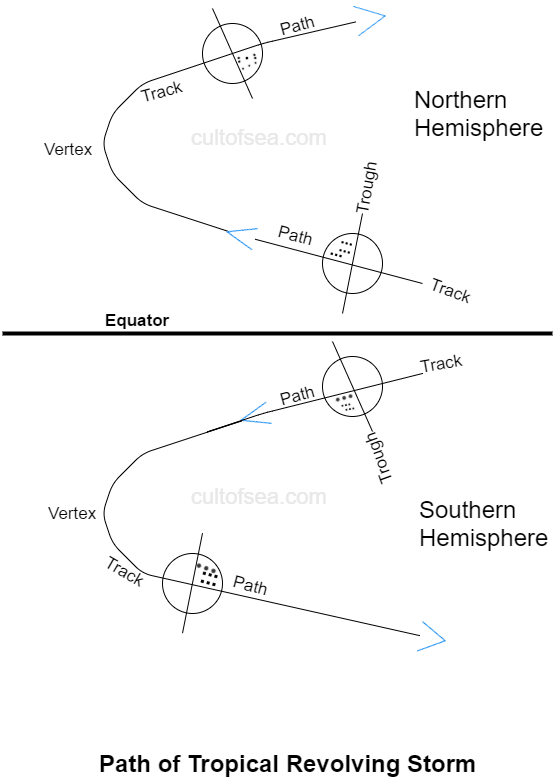
Origin, movement and life span
Path – The predicted route, over which, there is a possibility of the TRS passing at near future.
Another point on the route is called the Vertex, which is the westernmost point, of the TRS, when recurving takes place.
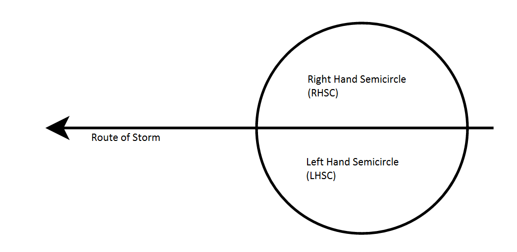
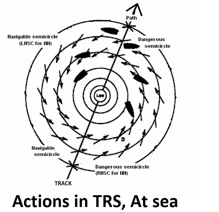
- Right-hand semicircle (RHSC): It is the half of the storm, which lies to the right of the observer, who faces along the route of the storm. For a stationary observer, here the wind veers steadily.
- Left-hand semicircle (LHSC): It is the half of the storm, which lies to the left of the observer, who faces along the route of the storm. For a stationary observer, here the wind backs steadily.
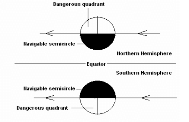
- Navigable semicircle — It is the side of a tropical cyclone, which lies to the left of the direction of movement of the storm in the Northern hemisphere (to the right in the Southern Hemisphere), where the winds are weaker and better for the navigation purpose, although all parts of TRS are more or less dangerous to mariners.
- Dangerous semicircle— It is the side of a tropical cyclone, which lies to the right of the direction of movement of the storm in the Northern Hemisphere (to the left in the Southern Hemisphere), where the storm has the strongest winds and heavy seas.
Structure
A well-developed TRS has three distinct parts:
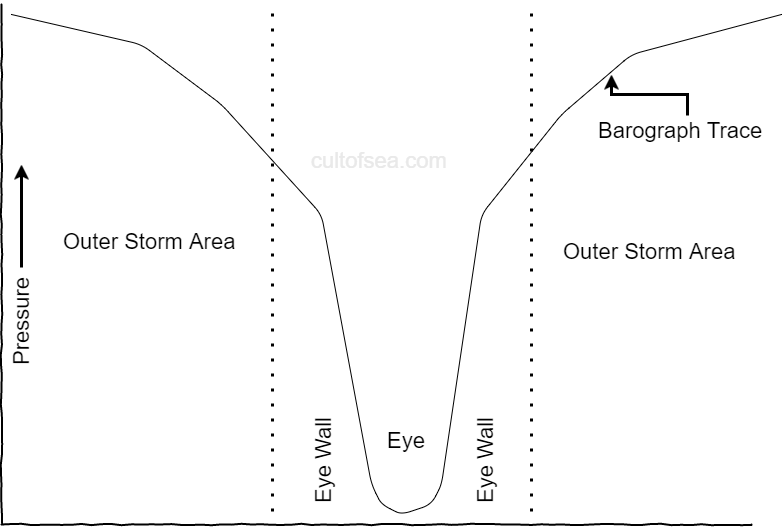
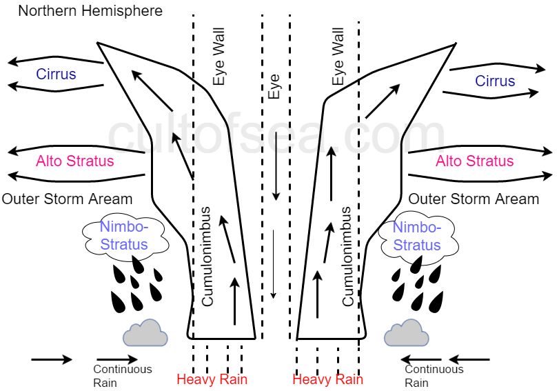
- The eye or vortex: A calm central area of lowest pressure, having a diameter between 4 miles and 30 miles, the average being about 10 miles. It is a roughly circular area of comparatively light winds and fair weather, available at the centre of a severe tropical cyclone. Weather in the eye is normally calm but the sea can be extremely violent. There is little or no precipitation and sometimes blue sky or stars can be seen. The eye is the region of lowest surface pressure than the surrounding environment. In severe cyclones, the eye usually looks like a circular hole in the central cloud mass.
- The eye-wall: An inner ring of hurricane force winds having a width usually between 4 miles and 30 miles. The winds in the eye-wall blow in a perfectly circular path with a speed as high as 130 knots with occasional gusts up to 150 knots. The pressure gradient in the eye-wall is very steep and, therefore, the barograph would register a near vertical trend, downward before the eye and upward behind it, as shown in the figure. Eye wall consists of a dense ring of cloud and tall thunderstorms that produce heavy diesel rains and usually the strongest winds (about force 6 or 7) at about circular path. Changes in the structure of the eye and eye wall can cause changes in the wind speed, which is an indicator of the storm’s intensity.
- The Outer storm area: The area surrounding the eye-wall, having a diameter between 50 miles and 800 miles, the average being about 500 miles. Winds in this region are strong (about force 6 or 7) and the pressure gradient is much less than in the eye-wall. Here angle of indraft of wind is about 45º and this gradually decreases to 0º in the eye wall. In this area, the cirrus cloud can be in the form of strands or filaments with aligned conditions and points towards the storm centre. Here visibility is excellent, except in occasional shower’s areas.
Life cycle of a tropical cyclone
The complete life cycle of a tropical cyclone usually spans about 9 days but can be only 2 or 3 days or more than 20 days.
Formation
The formation of a tropical cyclone is dependent upon six favourable environmental conditions (described before), which are available in the Inter Tropical Convergence Zone. Tropical cyclones gain energy from latent heat, driven by significant thunderstorm activity and condensation of moist air. In other words, tropical cyclone formation can be called as a gigantic vertical heat engine, which is also powered by earth’s gravity and rotation. On satellite images, this stage appears as an unusually active, but poorly organised area of convection (thunderstorms). Sometimes curved cumulus clouds band towards an active area of thunderstorms, which indicates the location of the centre. At this stage, if tropical cyclones move inland, then they make little or no damage but may form heavy rain and flooding in some areas.
Premature Stage
In this stage, the area of convection continues and becomes more organised. Also strengthening occurs simultaneously. The minimum surface pressure rapidly drops well below than normal level. Gale-force winds also develop with the strengthening pressure gradient. The circulation centre is well defined and subsequently, an eye may begin to form. Satellite and radar observations of the system show as the distinctive spiral banding pattern. Premature Stage of a tropical cyclone can cause devastating wind and storm surge effects upon coastline, but damage occurs usually within a small area.
Mature Stage
If the ocean and atmosphere environment continue to be favourable, the cyclone may continue to intensify to this stage. This is the severe cyclone stage, where the cyclone is most dangerous. Approximately half of the cyclones can come up to this stage. During this stage, the cyclonic circulation and extent of the gales increase markedly. In satellite images, the cloud fields look highly organised and become more symmetrical, with a well-centered, distinct round eye. This stage remains for a day or so with maximum intensity unless the cyclone remains in a highly favourable environment.
Decay Stage
At this stage, the warm core of TRS is destroyed, as the central pressure increases and the maximum surface winds weaken. Decay may occur very rapidly if the system moves into an unfavourable atmospheric or geographic environment. At this stage, the heavy or medium rain can be available.
Indications of approaching TRS
The signs and symptoms Of TRS/cyclone are as follows:
- Heavy and long swell from Cyclone centre. Swell can be experienced as much as a thousand miles away. Swell is usually the first indication of the storm centre, hence an approaching TRS.
- Pressure will be very much lower than the normal. When barometric pressure falls below 5 MB than normal, along with other TRS
confirmation factors, the approach of TRS is confirmed.
- Cirrus clouds in bands or filaments aligned towards the direction of the storm centre.
- At sunset, cloud colour will be dark red or copper.
- Clouds will be dense and heavy with threatening appearances.
- Frequent lighting will be experienced.
- Availability of storm warnings from the local authority. Weather reports based on satellite pictures and. observations from other vessels may contain storm warnings which give the position and pressure of the storm centre and also the probable direction of movement of the storm.
- The occurrence of squalls, which are increasing in frequency and intensity.
- The possibility of rain with violent torrential character.
- Sea waves are becoming heavy and dangerous.
- The shift of wind direction, in accordance with the rotation of winds of cyclonic spin.
Action when approach of a TRS is confirmed
- Obtain the bearing of the storm centre.
- Ascertain in which semi-circle the vessel lies.
- Take avoiding action.
1 Obtain the bearing of Storm Centre
- Face the wind, then the storm centre will be within 8 to 12 points on the right hand in NH (on the left hand in SH). – Buys Ballot’s Law
- The direction of the swell, this indicates roughly the storm centre.
- The direction of the densest part of the huge bank of clouds also indicates the storm centre.
If barometric pressure falls 5 MB below normal, then there is a possibility that ship is in the well developed outer storm area. If barometric pressure falls 20 MB or more below normal, then there is a possibility that ship is near the eye of a well developed TRS.
2 Ascertain in which semi-circle the vessel lies
Bring the ship in stationery or “heave to” (moving very slowly in one direction) to the position. Carefully monitor and write downwind directions, every after 2 hours. If wind direction changes clockwise (wind veers), than the vessel is at Right-hand semicircle (RHSC) and if wind direction changes anti-clockwise (wind backs), than the vessel is at Left-hand semicircle (LHSC), in both hemispheres.
Veering or backing, once detected, should be continuous while the observer remains stationary, i.e. a veering wind should continue to veer and a backing wind should continue to back. If the wind veers at first and then backs, or if it backs at first and then veers, the vessel must have passed from one semicircle into another, due to change of path of the storm.
3 Take avoiding action
Actions in TRS, at port
If possible, first try to go to sea at a safe distance with plenty sea room and sufficient depth of water. Else do the following:
- Double the moorings.
- Keep Engine standby.
- All persons to be onboard.
- Keep all LSA at the standby position.
- Rig lifeline at fore and aft.
- No slack tanks.
- All hatches should be securely battened down.
- All derricks should be lowered and secured.
- Adequate fenders should be placed between the ship and the jetty.
Actions in TRS, at anchorage
If possible, first try to go to sea at safe distance with plenty sea room and sufficient depth of water or shift to a safe anchorage with enough shelter. Otherwise, do the following:
- Drop both anchors with several cables in water.
- Keep Engine standby.
- All persons to be onboard.
- Keep all LSA at the standby position.
- Rig lifeline at fore and aft.
- No slack tanks.
- All hatches should be securely battened down.
- All derricks should be lowered and secured.
- All bridge equipment (including Radar, fog-horn) and navigational lights (including emergency navigational lights) should be in standby mode.
Actions in TRS, At sea
If the vessel is in the dangerous quadrant:
Proceed as fast as practicable with the wind 1 to 4 points on the stbd bow (port bow in SH) – 1 point for slow vessels (less than 12 knots) and 4 points for fast vessels (more than 12 knots) altering course as the wind veers (backs in SH).
This action should be kept up until the pressure rises back to normal i.e. until the vessel is outside the outer storm area. If there is insufficient sea room, the vessel should heave to with the wind on the stbd bow (port bow in SH) until the storm passes over.
If the vessel is in the path of the storm or if in the navigable semi-circle:
Proceed as fast as practicable with the wind about 4 points on the stbd quarter (port quarter in SH), altering course as the wind backs (veers in SH). This action should be kept up until the pressure rises back to normal i.e. until the vessel is outside the outer storm area.
The ideal conditions for the formation of a TRS exist during day time over large Tropical islands, in mid-ocean, between latitudes 5° & 20°
Excellent coverage for TRS and informative