
GMDSS Radio Signals Radio signals are transmitted as electromagnetic radiation and occupy the frequency range 3 kHz ~ 300 GHz. The radiofrequency range is divided into a number of bands. In the GMDSS system both terrestrial and satellite methods of communications are interlocked in order to provide an extremely reliable scheme to alert rescue authorities in the event of a vessel being in distress.Frequencies in the MF, HF and VHF bands are used for terrestrial communications via Coast Radio Stations (CRS). Frequencies in the SHF bands are used for satellite communications. It's important … [Read more...]
GMDSS Batteries Requirements

In Compliance with Solas Ch-IV, Reg 13 (Gmdss Batteries Requirement) A reserve source or sources of energy other than Ship's main and Emergency sources of electrical power shall be capable of operating GMDSS equipment's for:(a) 1 h on ships provided with an emergency source of electrical power(b) 6 h on ships not provided with an emergency source of electrical powerNote: The reserve source energy should also power emergency lighting fitted in the GMDSS console (reg 6.2.4) Battery Charger: When a means of automatically charging GMDSS batteries is provided , it should be capable … [Read more...]
How NAVTEX Works
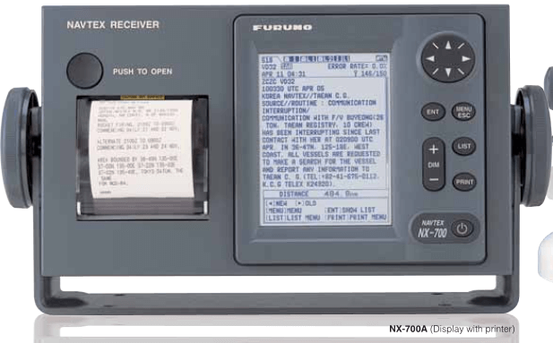
PRINCIPLE OF NAVTEX SYSTEMNAVTEX is an acronym meaning Navigational Telex, and as its name shows, it is a kind of narrow band radioteletype system for sending (by frequency shift keying) text messages expressed in a 7-unit code. The difference is that a NAVTEX transmitter transmits nine control characters (header code) ahead of the main message so that the receiver can identify the station, message type and serial number automatically. NAVTEX System Operation For navigation purposes, the world is divided into 16 areas as shown in the figure below. Each Navtex station has an … [Read more...]
Ship security alert system (SSAS)

The ship security alert system is again not a GMDSS communications system but it may be associated with GMDSS equipment installed on a ship. Carriage of SSAS is a requirement under theregulations of chapter XI-2 of SOLAS. The ship security alert system is fitted to a ship for the purpose of transmitting a security alert to the shore to indicate to a competent authority that the security of the ship is under threat or has been compromised.SSAS is a system that contributes to the International Maritime Organization's (IMO)'s efforts to strengthen maritime security and suppress acts … [Read more...]
EPIRB – Emergency Position indicating Radio Beacon
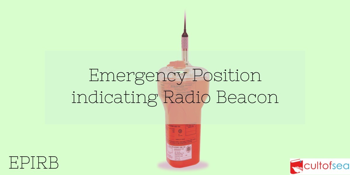
An Emergency Position Indicating Radio Beacon or EPIRB is a safety device carried by a vessel to alert search and rescue services and allow them to quickly locate you in the event of an emergency. It does this by transmitting a coded message on the 406 MHz distress frequency via satellite and earth stations to the nearest rescue coordination centre.An EPIRB usually works on 406/121.5 MHZ and can be manually or automatically activated and some models are also water activated. 121.5/243 MHz EPIRBs The International Cospas-Sarsat System ceased satellite processing of 121.5/243 MHz beacons … [Read more...]
EPIRB – Performance Standards (406Mhz)

Recommendation On Performance Standards For Float-Free Satellite Emergency Position-Indicating Radio Beacons (EPIRBs) Operating On 406mhz General 1. The satellite EPIRB should be capable of transmitting a distress alert to a polar-orbiting satellite.2. The EPIRB should be of an automatic float-free type. The equipment, mounting and releasing arrangements should be reliable, and should operate satisfactorily under the most extreme conditions likely to be met with at sea.3. The satellite EPIRB should: .1 be fitted with adequate means to prevent inadvertent activation; .2 be so … [Read more...]
GMDSS Radio Equipment Requirements on Ship as per SOLAS
The GMDSS radio equipment requirements are categorized as following:General Sea area A1 Sea areas A1 and A2 Sea areas A1, A2 and A3 Sea areas A1, A2, A3 and A4 Radio equipment: GeneralEvery ship shall be provided with:VHF radio capable of transmitting and receiving:-DSC on the frequency 156.525 MHz (channel 70) and maintain a continuous watch on the same -Radiotelephony on the frequencies 156.300 MHz (channel 6), 156.650 MHz (channel 13) and 156.800 MHz (channel 16);A search and rescue locating device (SART) capable of operating either … [Read more...]
Long Range Identification and Tracking ( LRIT )

Purpose Long Range Identification and Tracking or LRIT enables a Contracting Government to obtain ship identity and location information insufficient time to evaluate the security risk posed by a ship off its coast and to respond, if necessary, to reduce any risks.Long-range identification and tracking is also not a GMDSS communications system but it may use GMDSS equipment, particularly Inmarsat C terminals. LRIT is the subject of a new regulation included in chapter V of SOLAS which applies to ships constructed after 31 December 2008 with a phased-in implementation schedule for existing … [Read more...]
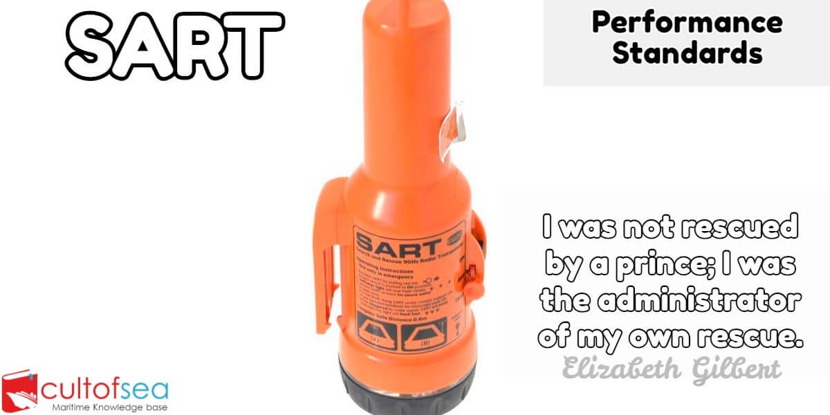
What is SART – Search and Rescue Radar Transponder?

A Search and Rescue Transponder (SART) is a self-contained, waterproof transponder intended for emergency use at sea. These devices may be either a radar-SART or a GPS-based AIS-SART (automatic identification system SART).The radar-SART is used to locate a survival craft or distressed vessel by creating a series of dots on a rescuing ship's radar display. A SART will only respond to a 9 GHz X-band (3 cm wavelength) radar. It will not be seen on S-band (10 cm) or other radar. Shipboard Global Maritime Distress Safety System (GMDSS) include one or more search and rescue locating … [Read more...]
SART – Performance Standards
Recommendation On Performance Standards For Survival Craft Radar Transponders For Use In Search And Rescue Operations The SART should be capable of indicating the location of a unit in distress on the assisting unit's radars by means of a series of equally spaced dots (resolution A.530(13)). 1. The SART should: .1 be capable of being easily activated by unskilled personnel; .2 be fitted with means to prevent inadvertent activation; .3be equipped with a means which is either visual or audible or both visual and audible, to indicate correct operation and to alert survivors to the fact that … [Read more...]