Twilight is the light received from the sun, when the sun is below the horizon, i.e. before the sunrise and after the sunset.
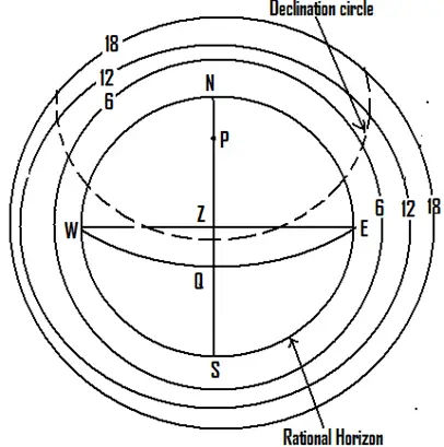
Twilight completely ceases in the evening, when the sun is 18° vertically below the horizon. After that, there is total darkness.
In the mornings, twilight commences when the sun is 18° vertically below the horizon and ceases at sunrise.
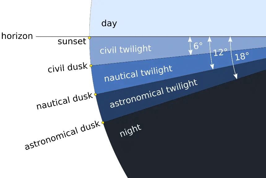
The entire period of twilight has 3 stages, Civil, Nautical and Astronomical.
- Astronomical commences when the sun is 18° below the horizon.
- Nautical – 12° below the horizon.
- Civil – 6° below the horizon.
Each twilight lasts until visible sunrise. In the evening, they all commence at visible sunset and Civil continues till the – sun is 6° below the horizon, Nautical continues till – the sun is 12° below the horizon and Astronomical continues till – the sun is 18° below the horizon.
Tables of the timings are provided in the Nautical almanac for commencement and end of Civil, Nautical and Astronomical twilight before sunrise and after sunset for different latitudes.

Periods of Twilight
Twilight last longer in higher latitudes as compared to lower latitudes
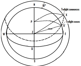
- As is evident from the below fig. when the observer is in low latitude, the sun rises and sets almost perpendicular to the horizon covering the 18° twilight belt in a rather short arc and therefore in a rather short period of time.
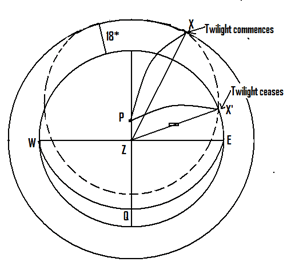
- When the observer is higher latitude however the sun rises and sets at a more oblique angle to the horizon, thus covering the 18° twilight belt over a much larger arc and therefore over a much larger period of time.


Lower latitude


Higher Latitude
Conditions necessary for twilight all night
For an observer to have twilight, the sun must set, therefore, he must have some night.
An observer would have some night for some part of the 24 hours, either –
1. If the observer’s latitude and the sun’s declination are of opposite name.
2. If, they are of the same name and the sum of the latitude and declination is less than 90°.
For continuous twilight, throughout the night, the observer’s latitude and sun’s declination should be of the same name and the limiting latitudes are obtained as:
1. lat + dec </= 90° (so that the sun will set), and
2. i. lat + dec + 18° >/= 90° (so that the sun will not go below the astronomical twilight belt and will have astronomical twilight throughout the night). Or
ii. lat + dec + 12° >/= 90° (so that the sun will not go below the nautical twilight belt and will have nautical twilight throughout the night). Or
iii. lat + dec + 6° >/= 90° (so that the sun will not go below the civil twilight belt and will have civil twilight throughout the night).
Conditions are necessary for continuous Daylight (Midnight Sun)
For continuous DAYLIGHT (Midnight Sun), the observer’s latitude and sun’s declination should be of the same name and the limiting latitudes are obtained as:
lat + dec >/= 90° (so that the sun will NOT set)
Conditions are necessary for continuous Night
For continuous Night, the observer’s latitude and sun’s declination should be of the different name and the limiting latitudes are obtained as: lat + dec >/= 90° (so that the sun will NOT RISE)
Theoretical and Visible Sunrise and Sunset
- Occurs when the True sun’s centre is on the observer’s rational horizon.
- Then the true altitude of the Sun is 0° and the true zenith distance 90°.
- The times of theoretical sunrise or sunset can be obtained by solving the PZX triangle in which ZX is 90°.
- Visible sunrise and sunset are not 0, because of corrections for refraction, semi-diameter, dip, etc.
- Assuming the Sun to be at the sea level, the true altitude of the Sun at visible sunrise and sunset is about 0 50′, the true zenith distance then is therefore 90 50′.
- Because of this visible sunrise occurs before theoretical sunrise and visible sunset after theoretical sunset.
- The nautical twilight lists the times for visible sunrise and sunset for various latitudes. Interpolation is required for intermediate latitudes.
How to identify a star which you have sighted during evening twilight, if you do not have any kind of a star constellation charts?
By referring to the Nautical Almanac
- Take a bearing & altitude of the star
- The correct GMT to be calculated.
- Then the LHA Aries is calculated.
- Using the PZX spherical triangle, lat, azimuth, altitude we first calculate the declination of the star and then the LHA star by calculating the angle P.
- LHA star – LHA Aries = SHA star
- Therefore using the declination and SHA of the star we can find the star by referring to the day page of the Nautical almanac.
Or
By referring to the Sight, Reduction tables.
- First we have to calculate the correct GMT.
- Then find out the LHA Aries.
- Take a visual bearing of the star and also, take the approx. altitude of the star.
- Using the LHA Aries, bearing and altitude of the star enter the Sight Reduction Tables for the present Latitude of the vessel.
- We can then identify the star having the closest values of LHA Aries, Azimuth and Altitude.
Conditions required for a body to rise bearing east
Irrespective of the observer’s latitude, the body will rise bearing east and set bearing west, when the body’s declination is 0⁰. Under this condition, the body will rise in the east, appear to move along the equinoctial and will set bearing west. Refer to below fig.

Also, when the observer is at the equator, a body with 0° declination will rise bearing east and continue to bear east till the body is at the observer’s zenith and thereafter will be bearing west till it sets.
Refer to below fig.


Leave a Reply